Dencukaay:Occupied Palestinian Territories.jpg

Dayoob bii wonendi: 393 × 599 pixel. Yeneen ñawaay: 157 × 240 pixel • 315 × 480 pixel • 504 × 768 pixel • 672 × 1 024 pixel • 1 895 × 2 889 pixel.
réyal nataal bi ((1 895 × 2 889 pixels, réyaayu file bi : 949 kio, type MIME : image/jpeg))
Faramfacce
| Faramfacce |
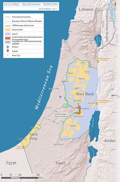
English: Map of the Occupied Palestinian Territories (West Bank and Gaza Strip), marked by the Green Line. Based on Reference Map: occupied Palestinian territory: Overview Map, as of December 2011. Published by United Nations Office for the Coordination of Humanitarian Affairs (OCHAoPt), 25 January 2012
العربية: خريطة للأراضي الفلسطينية المحتلة (الضفة الغربية وقطاع غزة) ، مميزة بالخط الأخضر. استنادًا إلى الخريطة المرجعية: "الأراضي الفلسطينية المحتلة: خريطة عامة" ، اعتبارًا من ديسمبر 2011. تم النشر بواسطة مكتب الأمم المتحدة لتنسيق الشؤون الإنسانية (OCHAoPt ) ، 25 يناير 2012 |
| Taariix | |
| Gongikuwaay | Sama liggéey, based on http://www.ochaopt.org/documents/ochaopt_atlas_opt_general_december2011.pdf on [1] |
| Aji-jëf | Wickey-nl |

|
Cette image (de type carte) devrait être recréée dans un format vectoriel, en tant que fichier SVG. Cela offrirait plusieurs avantages : voir Commons:Media for cleanup pour plus d'informations. Si une version SVG de cette image est déjà disponible, merci de bien vouloir l'envoyer. Après cela, remplacez ce modèle par {{vector version available|nouveau nom d'image.svg}}.
|


|
This file requires updating because: This indicates occupation in 2011, more than a decade ago -- far too old in this dynamic and contested region In doing so, you could add a timestamp to the file.
|
Anami Jëfandikoo gi
Moi, en tant que détenteur des droits d’auteur sur cette œuvre, je la publie sous la licence suivante :
Jàppandeeb bii dencukaay a ngi aju ci sañal gu Creative Commons Féetale-Séddoo ci gennug anam 3.0 Unported
- Féeg nga ci:
- séddoo – duppi, séddale ak yónnee bile liggéey.
- soppi – soppi liggéey bi
- Ci kaw yii anam:
- Moomale – Fàww nga joxe ay xibaar yu leer ñeel boroom, joxe ab lëkkalekaay buy jëme ci sañal gi te wax ndax def nga ciy coppite. Man nga koo def ci anam yu bari, ba mu des ci guy wund ne aji-moom ji dafa ànd ak yaw walla ànd na ci ninga koy jëfandikoo)
- Séeddoo ci gii anamam – Soo soppee walla nga defar leneen te sukkadiku ci bii liggéey, faww nga siiwal ko ci genn sañal gi walla geneen gum méngool

Jaar-jaaru dencukaay bi
Cuqal cib taariix/waxtu ngir gis ni dencukaay bi meloon ca jamono jooju.
| Taariix ak Waxtu | Tuutal | Dayoo | Jëfandikukat | Saraa | |
|---|---|---|---|---|---|
| teew | 25 Maars 2014 à 17:08 | | 1 895 × 2 889 (949 kio) | Wickey-nl | User created page with UploadWizard |
Xët yi am wii ŋara
Xët wii ci suuf ëmb na wii ŋara
Fépp fees jëfandikoo dencukaay bi
Yeneen wiki yiy toftal dañuy jëfandikoo itam bii dencukaay:
- Jëfandikoo nañu ko ci af.wikipedia.org
- Jëfandikoo nañu ko ci ar.wikipedia.org
- Jëfandikoo nañu ko ci az.wikipedia.org
- Jëfandikoo nañu ko ci bh.wikipedia.org
- Jëfandikoo nañu ko ci bn.wikipedia.org
- Jëfandikoo nañu ko ci bug.wikipedia.org
- Jëfandikoo nañu ko ci cs.wikipedia.org
- Jëfandikoo nañu ko ci da.wikipedia.org
- Jëfandikoo nañu ko ci de.wikipedia.org
- Jëfandikoo nañu ko ci el.wikipedia.org
- Jëfandikoo nañu ko ci en.wikipedia.org
- Israeli–Palestinian conflict
- Palestinian territories
- Israeli-occupied territories
- Frozen conflict
- United Nations Security Council Resolution 1515
- Talk:Israeli–Palestinian conflict/Archive 18
- United States involvement in regime change
- Boycott, Divestment and Sanctions
- Two-state solution
- Talk:State of Palestine/Archive 12
- Freedom of religion in Asia by country
- User:Falcaorib
- From the river to the sea
- User:Christophervincent01
- Jëfandikoo nañu ko ci es.wikipedia.org
- Jëfandikoo nañu ko ci et.wikipedia.org
- Jëfandikoo nañu ko ci fa.wikipedia.org
- Jëfandikoo nañu ko ci fi.wikipedia.org
- Jëfandikoo nañu ko ci fy.wikipedia.org
- Jëfandikoo nañu ko ci gl.wikipedia.org
- Jëfandikoo nañu ko ci he.wikipedia.org
- Jëfandikoo nañu ko ci hu.wikipedia.org
- Jëfandikoo nañu ko ci id.wikipedia.org
- Jëfandikoo nañu ko ci io.wikipedia.org
- Jëfandikoo nañu ko ci it.wikipedia.org
- Jëfandikoo nañu ko ci ja.wikipedia.org
- Jëfandikoo nañu ko ci la.wikipedia.org
- Jëfandikoo nañu ko ci lt.wikipedia.org
Wone njëfandikoo gu daj gu bii dencukaay.