Dencukaay:OIC countries map.png

Dayoob bii wonendi: 800 × 338 pixel. Yeneen ñawaay: 320 × 135 pixel • 640 × 270 pixel • 1 480 × 625 pixel.
réyal nataal bi ((1 480 × 625 pixels, réyaayu file bi : 43 kio, type MIME : image/png))
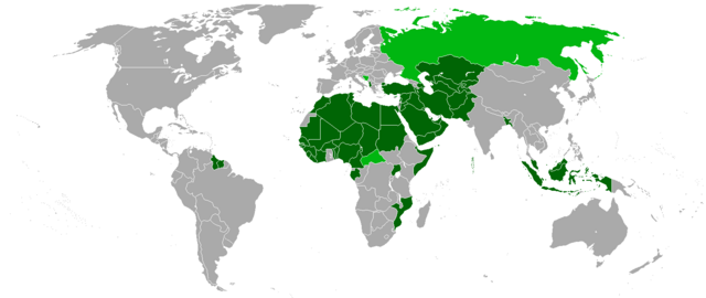
- Karte der Mitgliedsstaaten (dunkelgrün) und Beobachterstaaten (hellgrün) der Organisation der Islamischen Konferenz OIC
- Map of the member and observer states of the Organisation of the Islamic Conference OIC
Source
- Upload on http://de.wikipedia.org
- 01:09, 29. Jul 2005 . . St.Krekeler . . 969 x 579 (20772 Byte)

|
Sañalees na duppi, séddale ak/walla soppi bile liggéey ci anami GNU Free Documentation License, Sumb 1.2 walla bépp sumb buFree Software Foundation mujjee siiwal; bu amul benn pàcc bees manul soppi, te amul it menn mbind ci xët wu njëkk week wu mujj wi. Ab sotti bu sañal gi jàppandi na ci pàcc bees duppee GNU Free Documentation License. |
| Jàppandeeb bii dencukaay a ngi aju ci sañal gu Creative Commons Féetale-Séddoo ci gennug anam 3.0 Unported | ||
. | ||
| Ce bandeau de licence a été ajouté à ce fichier dans le cadre de la procédure de mise à jour des licences des images sous GFDL. |

|
Cette image (de type organization map) devrait être recréée dans un format vectoriel, en tant que fichier SVG. Cela offrirait plusieurs avantages : voir Commons:Media for cleanup pour plus d'informations. Si une version SVG de cette image est déjà disponible, merci de bien vouloir l'envoyer. Après cela, remplacez ce modèle par {{vector version available|nouveau nom d'image.svg}}.
|
| Annotations | This image is annotated: View the annotations at Commons |
Jaar-jaaru dencukaay bi
Cuqal cib taariix/waxtu ngir gis ni dencukaay bi meloon ca jamono jooju.
| Taariix ak Waxtu | Tuutal | Dayoo | Jëfandikukat | Saraa | |
|---|---|---|---|---|---|
| teew | 2 Fewriyee 2018 à 21:49 | | 1 480 × 625 (43 kio) | Maphobbyist | Added Maldives which is an OIC member and was forgotten. |
| 2 Fewriyee 2018 à 21:45 |  | 1 480 × 625 (43 kio) | Maphobbyist | Added borders of South Sudan which became independent in 2011 and which is not a member of the OIC. | |
| 1 Samwiyee 2018 à 18:05 |  | 1 480 × 625 (22 kio) | Nameless23 | Added missing western part of Malaysia | |
| 12 Suwe 2013 à 12:55 |  | 1 480 × 625 (32 kio) | Excolis | Maybe it works now | |
| 12 Suwe 2013 à 12:53 |  | 1 480 × 625 (32 kio) | Excolis | Now with Northern Cyprus as a light green marked state on the map. | |
| 26 Samwiyee 2011 à 15:17 |  | 1 480 × 625 (62 kio) | Kaiserslautern1993 | ||
| 26 Samwiyee 2011 à 15:06 |  | 1 480 × 625 (62 kio) | Kaiserslautern1993 | ||
| 15 Sattumbar 2008 à 17:02 |  | 1 357 × 628 (32 kio) | Milosevo | + Beobachter, + transparent background | |
| 21 Fewriyee 2008 à 21:29 |  | 1 357 × 628 (88 kio) | Leavade | Sahara hasn't signed | |
| 29 Samwiyee 2008 à 13:33 |  | 1 357 × 628 (52 kio) | Tariqhada | Reverted to version as of 17:09, 15 November 2007 |
Xët yi am wii ŋara
Xët wii ci suuf ëmb na wii ŋara
Fépp fees jëfandikoo dencukaay bi
Yeneen wiki yiy toftal dañuy jëfandikoo itam bii dencukaay:
- Jëfandikoo nañu ko ci als.wikipedia.org
- Jëfandikoo nañu ko ci ar.wikipedia.org
- Jëfandikoo nañu ko ci eo.wikipedia.org
- Jëfandikoo nañu ko ci fr.wikipedia.org
- Jëfandikoo nañu ko ci hr.wikipedia.org
- Jëfandikoo nañu ko ci ja.wikipedia.org