Dencukaay:Gambia satellite fires.jpeg
Dayoob bii wonendi: 800 × 242 pixel. Yeneen ñawaay: 320 × 97 pixel • 1 432 × 433 pixel.
réyal nataal bi ((1 432 × 433 pixels, réyaayu file bi : 103 kio, type MIME : image/jpeg))
Faramfacce
| Faramfacce |
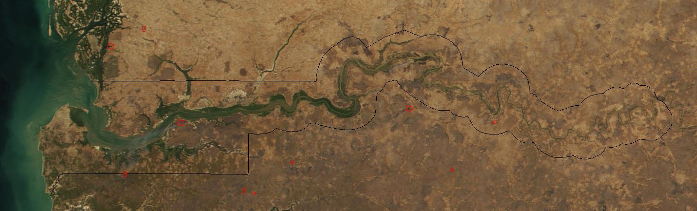
Image cropped to The Gambia. The red dots sprinkled all across this true-color image show the locations of fires mostly located in the African savannas just south of the Sahel region. Many fires were burning in this region throughout February 2002. This scene was acquired by the Moderate-resolution Imaging Spectroradiometer (MODIS), flying aboard NASA's Terra satellite, on Feb. 15. |
| Taariix | |
| Gongikuwaay | Cropped from: http://visibleearth.nasa.gov/view_rec.php?id=2521 |
| Aji-jëf | Jacques Descloitres, MODIS Land Rapid Response Team at NASA GSFC |
| Autres versions | Image:Senegal satellite fires.jpeg |
Anami Jëfandikoo gi
| Ce fichier provient de la NASA. Sauf exception, les documents créés par la NASA ne sont pas soumis à copyright. Pour plus d'informations, voir la politique de copyright de la NASA. | ||
 |
Attention :
|
Jaar-jaaru dencukaay bi
Cuqal cib taariix/waxtu ngir gis ni dencukaay bi meloon ca jamono jooju.
| Taariix ak Waxtu | Tuutal | Dayoo | Jëfandikukat | Saraa | |
|---|---|---|---|---|---|
| teew | 20 Disembar 2004 à 18:11 | 1 432 × 433 (103 kio) | Ikiwaner | Map from [http://visibleearth.nasa.gov/cgi-bin/viewrecord?12145 NASA Visible Earth] {{PD-USGov-NASA}} |
Xët yi am wii ŋara
Xët wii ci suuf ëmb na wii ŋara
Fépp fees jëfandikoo dencukaay bi
Yeneen wiki yiy toftal dañuy jëfandikoo itam bii dencukaay:
- Jëfandikoo nañu ko ci af.wikipedia.org
- Jëfandikoo nañu ko ci ar.wikipedia.org
- Jëfandikoo nañu ko ci ca.wikipedia.org
- Jëfandikoo nañu ko ci cs.wikipedia.org
- Jëfandikoo nañu ko ci cv.wikipedia.org
- Jëfandikoo nañu ko ci da.wikipedia.org
- Jëfandikoo nañu ko ci de.wikipedia.org
- Jëfandikoo nañu ko ci en.wikipedia.org
- Jëfandikoo nañu ko ci eo.wikipedia.org
- Jëfandikoo nañu ko ci es.wikipedia.org
- Jëfandikoo nañu ko ci fi.wikipedia.org
- Jëfandikoo nañu ko ci frr.wikipedia.org
- Jëfandikoo nañu ko ci fr.wikipedia.org
- Jëfandikoo nañu ko ci ha.wikipedia.org
- Jëfandikoo nañu ko ci he.wikipedia.org
- Jëfandikoo nañu ko ci ja.wikipedia.org
- Jëfandikoo nañu ko ci jv.wikipedia.org
- Jëfandikoo nañu ko ci mk.wikipedia.org
- Jëfandikoo nañu ko ci ms.wikipedia.org
- Jëfandikoo nañu ko ci nl.wikipedia.org
- Jëfandikoo nañu ko ci nn.wikipedia.org
- Jëfandikoo nañu ko ci pt.wikipedia.org
- Jëfandikoo nañu ko ci ru.wikipedia.org
- Jëfandikoo nañu ko ci sv.wikipedia.org
- Jëfandikoo nañu ko ci sw.wikipedia.org
- Jëfandikoo nañu ko ci uk.wikipedia.org
- Jëfandikoo nañu ko ci vi.wikipedia.org
- Jëfandikoo nañu ko ci xmf.wikipedia.org
- Jëfandikoo nañu ko ci zh.wikipedia.org